Showing posts with label Transit. Show all posts

Wednesday, May 18, 2011

Last One! Free Movie: Aperture, Friday, May 20, 11:30 AM


Join us for a free presentation of "Portland: Quest for the Livable City," which chronicles the tensions over sustainability efforts in Oregon’s largest metropolitan region

This is the last in our series of documentaries showing at Aperture Cinema in downtown Winston-Salem. Hope you can make it! 

311 West Fourth Street
Winston-Salem, NC 27101

Monday, May 9, 2011

Promoting Complete Streets and Context Sensitive Solutions

Complete Streets are designed to be safe and comfortable for all users, including pedestrians, bicyclists, transit riders, motorists and individuals of all ages and capabilities. Context Sensitive Solutions (CSS) is a approach to transportation system and road design that involves all stakeholders in designing transportation facilities that fit with their setting and surrounding land use.

Should Winston-Salem/Forsyth County pursue Complete Street and Context Sensitive Solutions as part of our transportation policy?

Give us your thoughts -- click "comments" below:

Reducing Auto-Dependence, Increasing Transit Use

Transit use benefits not only transit riders, but the whole community by reducing road congestion, auto emissions and reliance on foreign oil. Unfortunately, most trips in Forsyth County are made in a car, often a single-occupancy vehicle.

Given the benefits, how do we increase transit use in our community?

What changes need to occur to make transit easier and more enticing to use in our community?

Give us your thoughts -- click "comments" below:

Sunday, May 8, 2011

Housing + Transportation =
An affordable place to live?


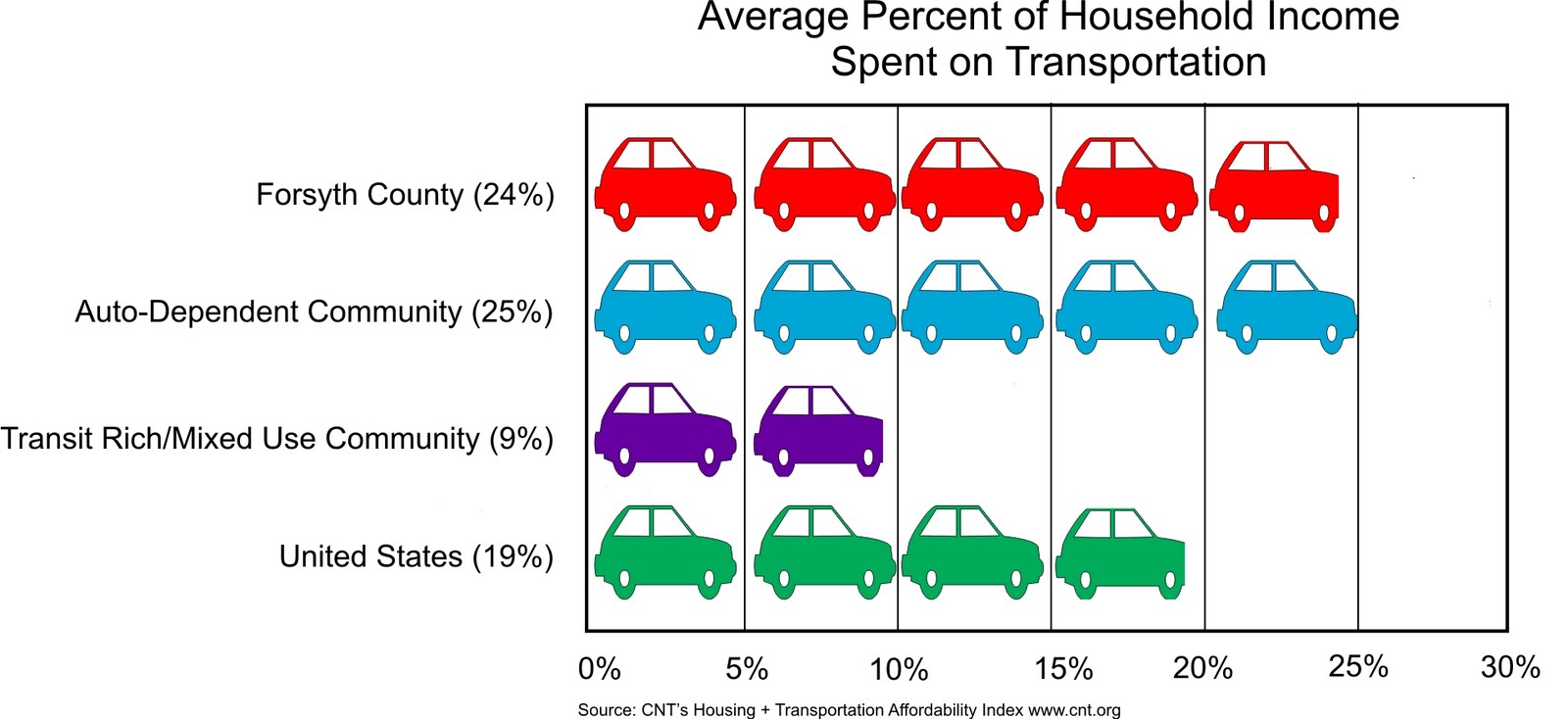
Calculations of housing affordability typically only includes housing costs and Americans typically consider housing to be affordable if it costs less than 30% of their income. The Center for Neighborhood Technology developed the Housing + Transportation Affordability Index to get a more complete assessment of affordability.  H+T takes into account the cost of transportation associated with the location of the home as well as housing costs. When transportation costs are factored in, cities with higher housing cost, but with good transit systems and diverse transportation options are often more affordable than auto-dependent suburban and rural locations.

Commute Solutions uses a more comprehensive calculation of commuting costs by factoring in out-of-pocket direct driver's expenses and the indirect costs of driving, including road construction, air and water pollution, congestion and land use impacts. Their cost figures are for California, but the list of indirect costs is educational and thought-provoking. 

Transit, Walkable Communities and Gas Prices

Transit use benefits the entire community by providing cost-efficient transportation choices while providing access to jobs and health care and reducing congestion on roadways. Work completed since the adoption of Legacy includes the Central City Streetcar Study, the Regional Commuter Rail Study and the Human Services Coordination Plan. There has even been some increase in transit ridership since the adoption of Legacy. The highest year for ridership was 2009 after gas prices exceeded $4 a gallon. Regional transit has enjoyed even larger increases; ridership quadrupled between 2003 and 2010.

Transit/pedestrian-oriented design also needs to be utilized more by the community to create the livable, walkable communities that Legacy calls for. However, there are still issues as to whether the community should be more prescriptive concerning the design of pedestrian-friendly developments, even in the urban areas.

Saturday, May 7, 2011

Complete Streets

A Complete Street in Charlotte

Complete streets, sometimes called multi-modal streets, are designed to be safe and comfortable for all users including pedestrians, bicyclists, transit riders, motorists and individuals of all ages and capabilities. These streets generally include sidewalks, bicycle lanes, transit stops, appropriate street widths and speeds, and are well-integrated with surrounding land uses. Complete Street design elements that emphasize safety, mobility and accessibility for multiple modes and may include crosswalks, bus lanes, landscaping, lighting, signaling systems and adequate separation between sidewalks and streets. Many jurisdictions have adopted Complete Streets policies to make accommodation of all users as an expected part of transportation projects. Charlotte recently won a national award for its attention to complete street policies. To implement these policies, jurisdictions are developing design guidelines and/or regulations.

Monday, May 2, 2011

Encourage Transit Oriented Development (TOD)

 How and where can we use the TOD concept (involves a mixture of increased residential densities, retail and offices clustered at specific locations along a transit line) to place housing and job locations in closer proximity and reduce trip miles? 

How can we promote development that can be conducive to a transit station locating there in the future?

Give us your thoughts -- click "comments" below:

Increased Density Along Corridors

Roads such as Peters Creek Parkway and University Parkway lend themselves to an increased residential density and potential transit corridors.


How do we build a successful transit system through attractively-designed, increased-density developments along partially-developed corridors?

How do we help transform these corridors from strips into a complementary mixture of uses?

Give us your thoughts -- click "comments" below:

Transportation in Downtown
and Central Winston-Salem

What alternative means of transportation do we need in our center city to help move people between activities and to promote higher-density development and mixed uses?

Give us your thoughts -- click "comments" below:

How does Land Use Relate to Transportation?


Land Use patterns do not happen in a vacuum, they are dependent on other features such as the transportation system and location of utilities. Before we can determine tools for changing our land use patterns, we must consider how these elements influence land use in our community.

The current relationship between land use and transportation in Forsyth County is that our low-density land use pattern is extremely auto-dependent. In most cases, people have to drive to get from their home to shopping, services or work. Transit use remains fairly low in our county. Currently, daily vehicle miles in Forsyth County translate into 30.5 miles per day for every person in the county.

The remainder of the Land Use Discussion will include questions that are also related to transportation.

Monday, April 18, 2011

The Big Question: Where will 120,000 People Go?


Forsyth County is expected to see a net increase of 120,000 new residents and 66,000 new jobs move to our communities. Where will these new residents live and work and how will we preserve the good qualities of our county while accommodating necessary new development? How will we preserve prime acreage for employment centers that are currently undeveloped but are zoned for single-family development? What is the most economical way for our community to develop and receive services in a way that helps keep taxes from increasing? To answer these questions, it is necessary to understand our options for future growth and make a deliberate choice about how our community moves forward. The Growth Management Plan can be an important tool in implementing any chosen growth strategy.

Due to the prominence of low-density residential development patterns in recent decades, Forsyth County has only 62,000 acres of undeveloped land left which is capable of supporting urban and suburban growth. This area of land will be referred to in the Legacy Update as the “Serviceable Land Area.” While 62,000 acres may sound like a lot of land, incorporated Winston-Salem and the surrounding small municipalities could be built-out in 25 years if current development patterns continue. How quickly the remaining 62,000 acres of Serviceable Land Area are developed depends on the availability of the land and the timing and density of  the development. The lower the density of any new development, the more quickly our remaining land will be used up.

Since 1950, Winston-Salem’s density has dropped dramatically (63%, from 7.3 persons per acre to 2.7 persons per acre) due to suburbanization and smaller household size (the number of persons living in each dwelling unit). The other municipalities in Forsyth County have even lower overall densities ranging from 0.6 persons per acre in Tobaccoville to 2.4 persons per acre in Clemmons.

Tuesday, April 12, 2011

Implications of Demographic Changes for Future Planning

 
Forsyth County Selected Demographics
Hispanic
African-American
White
Asian
Overall
1990 Percent of Forsyth County Population
0.8%
24.8%
73.6%
0.6%
2010 Percent of Forsyth County Population
11.9%
25.5%
58.7%
1.8%
1990-2010 Percent of Forsyth County Population Growth
46.8%
27.9%
12.1%
5.6%
2009 Median Age
24.1
33.4
42.1
33.6
37.1
2000-2009 Pre-Seniors Growth (55-64 years old)
133.3%
53.6%
34.8%
159%
41.1%
2009 Median Household Income
$32,240
$33,502
$55,492
$64,819
$47,438
2009 Percent Owner-Occupied Housing
35%
47.5%
77.4%
54.3%
66.9%
2009 Percent with High School Degree
52.4%
85.2%
90.2%
92.1%
86.3%
2009 Percent with Bachelor's Degree
12.5%
21.7%
35.2%
61.2%
30.8%
2009 Percent Living Below Poverty Level
36.2%
24.3%
7.4%
6.4%
14.6%

The Brookings Institute in State of Metropolitan America (2010) describes several major national demographic trends from the past decade that can be expected to continue into the next couple of decades including: Population Diversification, Aging Population and Income Polarization.

How does this impact planning? Let's start here:
  • Increasing diversity introduces needs for more diverse residential options with better accessibility to jobs
  • Aging population will demand more walkable, mixed use environments
  • Dispersed, low-density residential pattern makes it difficult and costly to provide transportation options for older populations, single-parent households and households sensitive to gas prices
  • Growth in knowledge-based economy creates demands for more vibrant urban living options for “Gen-X” workers
  • We're starting to see new trends in net increase in college-educated workers, and more urban living 

Friday, March 25, 2011

Videos: Making Sense of Place


The Making Sense of Place videos examine the complex questions of urban planning and regional identity by exploring the ways people participate in and experience their cities. The series illuminates the tensions between growth, economic development and quality of life in downtown areas, local neighborhoods and surrounding regions by closely examining these issues in Phoenix, Cleveland and Portland. All of these issues are pertinent to Winston-Salem and Forsyth County, so this May the City-County Planning Board, in partnership with Aperture Cinema in downtown Winston-Salem, is showing the entire series. These one-hour films will be shown at 11:30 AM on three consecutive Fridays: May 6th, 13th and 20th. These are all free and open to the public.
If you can't make it to Aperture, you can watch each of them on your computer:

Phoenix: The Urban Desert explores the interrelationships both caused by and affecting individual choices, the democratic process and market forces in the region.

Cleveland: Confronting Decline in an American City is a compelling examination of the difficulties in reversing the cumulative effects of urban decline.

Portland: Quest for the Livable City examines the complex challenges of becoming a more sustainable metropolis.

311 West Fourth Street
Winston-Salem, NC 27101