Showing posts with label Chapter 5. Show all posts

Tuesday, June 21, 2011

Six Questions About Growth


How do you think 120,000 new people will affect Land Use, Transportation, Economic Development, Environmental Quality & Sustainability, Community Character, and Community Health in Forsyth County?

And, if you didn't make it to our most recent community input session, watch this video to learn more about how this coming growth will affect your community.

June 7th Meeting at WSSU Anderson Center

Monday, May 9, 2011

Promoting Livable Streets and Traffic Calming

Creating livable streets and communities starts with street design that makes walking, cycling and transit use desirable while providing a mix of land uses built at a human scale. Livable street design can be applied to both new and existing development. One way to apply the livable design concept to existing neighborhoods is through traffic calming. The City of Winston-Salem adopted a traffic calming policy in 2003 to promote safety for motorists, bicyclists and pedestrians while enhancing the appearance neighborhoods.

Is Winston-Salem’s current traffic calming program working?

Do other communities in Forsyth County need to take actions related to traffic calming?

What land use and transportation strategies should be developed to create pedestrian-friendly, livable communities that increases transit use?

Give us your thoughts -- click "comments" below:

Promoting Complete Streets and Context Sensitive Solutions

Complete Streets are designed to be safe and comfortable for all users, including pedestrians, bicyclists, transit riders, motorists and individuals of all ages and capabilities. Context Sensitive Solutions (CSS) is a approach to transportation system and road design that involves all stakeholders in designing transportation facilities that fit with their setting and surrounding land use.

Should Winston-Salem/Forsyth County pursue Complete Street and Context Sensitive Solutions as part of our transportation policy?

Give us your thoughts -- click "comments" below:

Promoting Street Connectivity

Street connectivity takes congestion off major roads and provides a more efficient delivery of municipal services. The result is a reduction in fuel costs for both citizens and government. However, residents often oppose connections of new roads to existing roads for fear of seeing an increase in traffic on their own streets.

How do we promote the benefits of a connected street system?

What standards do we establish for street connectivity in existing neighborhoods and new developments?

Give us your thoughts -- click "comments" below:

Reducing Auto-Dependence, Increasing Transit Use

Transit use benefits not only transit riders, but the whole community by reducing road congestion, auto emissions and reliance on foreign oil. Unfortunately, most trips in Forsyth County are made in a car, often a single-occupancy vehicle.

Given the benefits, how do we increase transit use in our community?

What changes need to occur to make transit easier and more enticing to use in our community?

Give us your thoughts -- click "comments" below:

Regionally Coordinated Transportation Planning

A good regional transportation system is important for attracting and retaining businesses and residents. A myriad of agencies and boards are responsible for transportation planning at the local and the regional level. The Piedmont Authority for Regional Transportation (PART) serves as a regional transportation planning agency which also undertakes efforts to promote regional mobility and sustainable growth patterns in the Triad.

How should transportation planning responsibilities be coordinated among organizations?

Should one agency have ultimate responsibility or authority?

Give us your thoughts -- click "comments" below:

Integrating Land Use and Transportation Decision Making

Unfortunately, land use planning and transportation investment decisions are often made by different entities and/or levels of government. Land use decisions are typically made at the local level, while transportation decisions are made at the local, regional, state and federal levels. In turn, the transportation decision makers at the various levels need to consider the effects the existing and future transportation systems may have on land use patterns.

How do we better integrate land use and transportation decision making?

How do we get decision makers to consider both land use and transportation when considering development sites, development regulations or public investment decisions?

Give us your thoughts -- click "comments" below:

Community Discussion: Transportation

Look for the Discussion Bubble for specific community issues that can help us develop a growth strategy. Most relate to our three Legacy Update themes: Sustainable Growth, Livable Design and Fiscal Responsibility.

Like most communities, Forsyth County is changing its view of what transportation planning should entail. Below is a list of specific community issues for discussion that can help us to develop a comprehensive transportation strategy.

Long Range Transportation Plans


The Winston-Salem Urban Area, which includes almost all of Forsyth County and portions of Davidson, Davie and Stokes Counties, has several long range transportation plans/processes: the Long Range Transportation Plan (LRTP), the Comprehensive Transportation Plan (CTP), and the Metropolitan Transportation Improvement Program (MTIP). The LRTP includes all modes of transportation, and is fiscally constrained as it only includes projects for which funding is anticipated. The LRTP is required under federal provisions and must include an assessment of air quality impacts.

The State transportation planning requirement is the Comprehensive Transportation Plan (CTP). The CTP is a long range plan for all modes of transportation and is not fiscally constrained. The Street and Highway component of the CTP serves as the street and highway master plan for the urban area by identifying both existing roads and the general location of future planned roads.

The Metropolitan Transportation Improvement Program (MTIP) is the official transportation investment schedule for State and federally-funded surface transportation projects planned within the Metropolitan Area. The MTIP programs project funding for a seven-year period for all modes of transportation.

What are other communities doing?


Successful long range transportation plans from Raleigh and Denver were studied. These two plans share many of the same components which work toward a  comprehensive and inclusive approach.

Denver’s transportation plan recognizes the importance of a multi-modal transportation network. The success of a multi-modal system hinges on the strength of the system’s connections and the opportunity for diverse mobility options within the system. The street system, public transit system, bicycle system and pedestrian system all must work together to provide a complete transportation network. The plan also recognizes the link between transportation, land use and transit-oriented development. By implementing the plan, Denver will develop a transportation system that balances the needs of all modes of travel, providing the public with multiple transportation options.

The City of Raleigh’s transportation plan recognizes the importance of developing a balanced, efficient, multi-modal transportation network that minimizes impacts to the environment and reinforces the livability of neighborhoods. The plan recognizes that in the future not only will existing facilities and services need to be improved, but new mobility options, including increased and higher-capacity transit service, will need to be created. The plan contains policies that will create a well-connected, multi-modal transportation network, support increased densities, help walking become more practical for short trips, support bicycling for short- and long-distance trips, improve transit, conserve energy resources and reduce greenhouse gas emissions and air pollution.

Alphabet Soup:
Who's Who in Transportation

Winston-Salem Metropolitan Planning Organization Boundaries

Numerous organizations are involved in transportation planning in Forsyth County:

WSDOT - Winston-Salem Department of Transportation plans, designs, constructs and operates the system of bike routes, roads and traffic signals in Winston-Salem to aid the flow of traffic and minimize congestion.

MPO - The Metropolitan Planning Organization is responsible for carrying out the transportation planning process in the Winston-Salem Urban Area. The Winston-Salem Department of Transportation serves as the Lead Planning Agency and provides primary staff for the Winston-Salem Urban Area MPO.

TAC - The Transportation Advisory Committee is the decision making body of the MPO and is composed of elected officials from Forsyth County, the City of Winston-Salem and other member governments as well as representatives from other organizations. The TAC serves as a forum for cooperative transportation planning and is responsible for approving planning documents and reports.

TCC - The Technical Coordinating Committee is composed of key staff representatives from the MPO member governments and other local, State and federal government agencies which are directly related to and concerned with the transportation planning process for the Winston-Salem Urban Area. The TCC makes recommendations to the TAC based upon technical expertise.

PART - The Piedmont Authority for Regional Transportation serves as a regional transportation planning agency which also undertakes efforts to promote regional mobility and sustainable growth patterns in the Triad. PART is best known for its regional bus routes and van pooling program.

NCDOT - The North Carolina Department of Transportation is primarily responsible for State road maintenance and safety programs. The NCDOT also oversees the administration of federal/State money for projects that benefit the traveling public, helps communities increase transportation choices and access, and works to enhance the environment.

Sunday, May 8, 2011

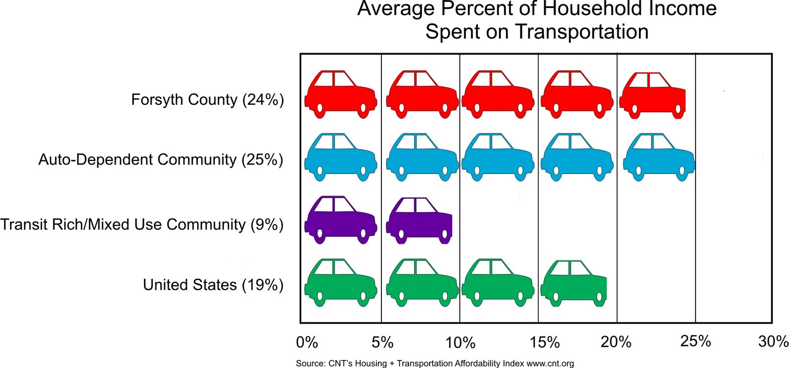
Housing + Transportation =
An affordable place to live?


Calculations of housing affordability typically only includes housing costs and Americans typically consider housing to be affordable if it costs less than 30% of their income. The Center for Neighborhood Technology developed the Housing + Transportation Affordability Index to get a more complete assessment of affordability.  H+T takes into account the cost of transportation associated with the location of the home as well as housing costs. When transportation costs are factored in, cities with higher housing cost, but with good transit systems and diverse transportation options are often more affordable than auto-dependent suburban and rural locations.

Commute Solutions uses a more comprehensive calculation of commuting costs by factoring in out-of-pocket direct driver's expenses and the indirect costs of driving, including road construction, air and water pollution, congestion and land use impacts. Their cost figures are for California, but the list of indirect costs is educational and thought-provoking. 

Transit, Walkable Communities and Gas Prices

Transit use benefits the entire community by providing cost-efficient transportation choices while providing access to jobs and health care and reducing congestion on roadways. Work completed since the adoption of Legacy includes the Central City Streetcar Study, the Regional Commuter Rail Study and the Human Services Coordination Plan. There has even been some increase in transit ridership since the adoption of Legacy. The highest year for ridership was 2009 after gas prices exceeded $4 a gallon. Regional transit has enjoyed even larger increases; ridership quadrupled between 2003 and 2010.

Transit/pedestrian-oriented design also needs to be utilized more by the community to create the livable, walkable communities that Legacy calls for. However, there are still issues as to whether the community should be more prescriptive concerning the design of pedestrian-friendly developments, even in the urban areas.

Saturday, May 7, 2011

Complete Streets

A Complete Street in Charlotte

Complete streets, sometimes called multi-modal streets, are designed to be safe and comfortable for all users including pedestrians, bicyclists, transit riders, motorists and individuals of all ages and capabilities. These streets generally include sidewalks, bicycle lanes, transit stops, appropriate street widths and speeds, and are well-integrated with surrounding land uses. Complete Street design elements that emphasize safety, mobility and accessibility for multiple modes and may include crosswalks, bus lanes, landscaping, lighting, signaling systems and adequate separation between sidewalks and streets. Many jurisdictions have adopted Complete Streets policies to make accommodation of all users as an expected part of transportation projects. Charlotte recently won a national award for its attention to complete street policies. To implement these policies, jurisdictions are developing design guidelines and/or regulations.

Making the Connection

Street connectivity refers to the directness of links and the density of connections of the road network. For many years, new developments were not required to provide connections which is now causing congestion on many of our roads. Benefits of connectivity include a decrease of traffic on arterial streets, shorter travel distances, more direct routes that encourage travel by walking and bicycling, quicker response times for emergency vehicles and more efficient trash and recycling collection.

Many jurisdictions have adopted connectivity regulations, the most common method is to establish a maximum block length. Another method is to establish a “connectivity index” that must be met in new developments. The current street standards adopted for Winston-Salem/Forsyth County establish a minimum connectivity index for new subdivisions of 1.2 and a maximum cul-de-sac length of 800’ unless deemed impractical due to topography, existing development or natural obstacles.

Street connectivity standards are used primarily in new developments but could also be used when considering connections in existing neighborhoods. Because street connectivity disperses traffic, some jurisdictions connect existing streets as an alternative to road widening.

Context Sensitive Solutions

Context Sensitive Solutions (CSS) is a collaborative, interdisciplinary approach that involves all stakeholders in providing a transportation facility that fits its setting. It is an approach that leads to preserving and enhancing scenic, aesthetic, historic, community and environmental resources, while improving or maintaining safety, mobility and infrastructure conditions. 

Friday, May 6, 2011

As our population rises,
so does our time in the car

The Sustainable Choices VMT projection is based on studies that show compact, mixed-use communities with broad transportation choices can reduce VMT by 20-40%
For most people, the car still dominates as the transportation mode of choice in Forsyth County and the Triad. The time citizens spend in the car and the number of miles driven continues to rise at a rate higher than the population growth rate. While local transit ridership has increased, it is more likely due to higher gas prices than a change in our development patterns.

Livable, Walkable Communities


The goal of transit/pedestrian-oriented design is to create livable, walkable communities where the pedestrian is the priority. Transit/pedestrian-friendly design goes far beyond simply providing sidewalks, bike lanes and bus stops, both land use and the transportation system must be designed to support and encourage alternative forms of transportation. Land uses need to be diverse and located in close proximity to transportation facilities.  Design needs to be at a human scale with buildings pulled up to the street and parking lots and driveways located to minimize their visibility and impact. Higher densities must exist at appropriate locations to create a critical mass of residents that make transit feasible.

There are many overlaps between transit/pedestrian-friendly design and traffic calming/livable streets initiatives, and many of the design techniques can apply when retrofitting existing development. Traffic calming programs, also known as “neighborhood traffic management” are design techniques used to slow down and control the flow of traffic in neighborhoods and other special focus areas. Measures often include placing speed humps and bulb-outs in the roadway, narrowing travel lanes by placing medians and bike lanes in the roadway, installing sidewalks and/or street trees, and installing street islands and well-marked, signalized crossings to increase pedestrian safety and slow traffic.

More Than a Driveway Permit

Lewisville-Clemmons Road
Access Management is a term used by transportation professionals for coordination between roadway design and land use to improve transportation. Access management is “the process that provides access to land development while simultaneously preserving the flow of traffic on the surrounding road system in terms of safety, capacity, and speed.” Access management strategies help maintain the capacity and safety of roadways and reduce conflicts between vehicles, pedestrians and bicyclists. In its most basic form, access management is a driveway permit. But access management strategies can also include limiting the number and location of driveways and intersecting streets, requiring combined driveways or the construction of frontage roads, limiting driveway access to side or rear roads or alleys, requiring the construction of frontage roads and constructing medians to control turning movements.

Keeping you in the loop


One major project that has been on the books for years in Forsyth County is the Northern Beltway. The project is made up of three sections for a total length of 34 miles. Unfortunately, the project has been tied up due to numerous issues from problems with the Environmental Impact Statement to changes in how the State allocates money for beltway projects. Many people in the community see this project as crucial both from a traffic management standpoint as well as an essential economic development driver. Citizens with properties in the right-of-way have been left holding properties they can neither sell or improve.